PJ5-CCTRLow-power (unlicensed) wireless device for leisure
Flir Belgium BVBA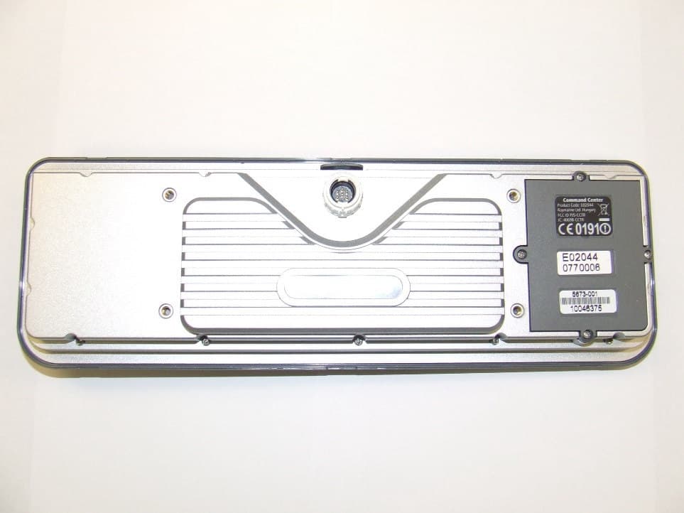
Click to zoom
Application Details
- Equipment Class
- DTS - Digital Transmission System
- Date of Grant
- Feb 04, 2008
- Application Purpose
- Original Equipment
- Date of Application
- Feb 04, 2008
- Equipment Note
- Low-power (unlicensed) wireless device for leisure
- Frequency Range
- 2400.00000000 - 2483.50000000
- Company
- Flir Belgium BVBA
- Country
- Belgium
Documents & Files
Document Text
Text extracted from the exhibit documents filed with the FCC. Open a document above to read the original.
Users Manual
G-Series Systems Reference Guide G-Series SystemReference GuideDocument Number: 81276-1Date: June 2007 G-Series Reference Manual 4 Trademarks and registered trademarksAutohelm, HSB, Raymarine, RayTech, Sail Pilot, SeaT alk and Sportpilot are registered trademarks of Ray marine Limited. Apelco is a regis- tered trademark of Raymarine Holdings Limited (Regi stered in all major marketing territories). AST, Autoadapt, Auto GST, Autoseastate, Autotrim, Bidata, Marine Intelligence, Maxiview, On Board, Raychart, Raynav, Raypilot, Raystar, ST40, ST60, Seaclutter, Smart Route, Tridata and Wa ypoint Navigation are trademarks of Raymarine Limit ed. Maptech is a registered trademark of Maptech.All other product names mentioned are trademarks or registered trademarks (if applicable) of their res pective companies © Raymarine plc 2007 5 ContentsChapter 1: System Overview ........................ .... 13 1.1 Hardware overview ............................. ..................... 14 1.2 Display and keyboard .......................... .................... 15 1.3 Installing and commissioning .................. ................. 17 1.4 System applications ........................... ...................... 17 Chapter 2: Operating Principles ........................ 21 2.1 Introducing Nav Stations ...................... .................... 22 2.2 Using the applications ........................ ...................... 22 2.3 Displaying applications ....................... ..................... 25 2.5 Simulator mode ................................ ........................ 29 2.6 Emergencies and warnings ...................... ................ 29 Chapter 3: Nav Station Setup ...................... ..... 31 3.2 Monitor settings .............................. .......................... 32 3.3 Keyboard settings ............................. ....................... 33 3.4 Setting language, date and time, and units of m easure- ment .............................................. ................................. 33 3.5 Local settings ................................ ........................... 33 Chapter 4: Using Waypoints ............................. 35 4.1 Introducing waypoints ......................... ..................... 36 4.3 Waypoint list ................................. ............................ 38 4.4 Placing waypoints ............................. ....................... 38 4.5 Navigating to waypoints ....................... .................... 39 4.6 Waypoint information .......................... ..................... 39 4.7 Editing waypoints ............................. ........................ 39 4.8 Sorting the waypoint list ..................... ...................... 41 4.9 Waypoint groups ............................... ....................... 41 Chapter 5: The Chart Application ...................... 43 5.1 Warnings and cautions ......................... ....................44 5.2 Supplied cartography .......................... .....................44 5.4 Chart setup ................................... ............................46 5.8 Heading and course information ................ ..............62 5.10 Showing and hiding waypoints ................. ..............64 5.11 Chart layers ................................. ...........................64 5.12 Chart mode and orientation ................... .................66 5.13 Chart view ................................... ...........................68 5.14 Chart detail ................................. ............................68 5.15 Journey planning ............................. .......................69 5.16 Measuring distance, range and bearing ........ .........73 Chapter 6: 3D Chart ............................... ........... 75 6.1 Safety notice .................................. ...........................76 6.2 3D chart requirements .......................... ....................76 6.3 Setting up the 3D chart ....................... ......................76 6.4 The 3D chart view ............................. .......................76 6.5 Operation modes ............................... .......................77 6.8 Tuning the view ............................... .........................81 6.9 Using the standard and 3D charts together ...... ........83 6.10 Aerial photography overlay ................... ..................84 Chapter 7: Autopilot Integration .................. ...... 85 7.1 Emergency disengage ........................... ...................86 7.2 Enabling and engaging the autopilot ........... .............86 7.3 Autopilot Status Indicator ..................... ....................86 7.4 The autopilot control screen .................. ...................87 7.5 Waypoint arrival .............................. ..........................87 G-Series Installation & Commissioning 6 Chapter 8: The Fishfinder ......................... ........91 8.1 The fishfinder display ........................ ....................... 92 8.2 Background information ........................ ................... 92 8.3 Operating the fishfinder ...................... ..................... 92 8.4 Explaining the readout ........................ ..................... 93 8.5 Factors influencing the readout ............... ................ 93 8.8 Adjusting gain and power ...................... ................ 102 8.9 Measuring depth and distance .................. ............ 103 8.10 Fishfinder alarms ............................ ..................... 105 8.11 Editing presets .............................. ....................... 105 8.12 Fishfinder configuration ..................... .................. 107 Chapter 9: Sirius Weather (US only) ...............111 9.1 Disclaimer .................................... .......................... 112 9.2 Weather application pre-requisites ............ ............ 112 9.3 Weather application setup ..................... ................ 112 9.4 The weather display ........................... .............…
Text truncated - open the document above for the full version.
Users Manual
G-Series Reference Manual 112 9.1 Disclaimer For disclaimer see page 218 . 9.2 Weather application pre-requisites Before you can use the weather application you need to: • Obtain a Sirius ID number. (For full details, see the Sirius Instal- lation handbook.) • Customize a page set to include a weather applicati on. • Specify the weather elements that you wish to disp lay. • For the G-Series system to display weather data, i t must be connected to an SR100 Sirius Receiver which is supp lying the appropriate data. • For your vessel to be displayed and for weather re ports to be available at your position, you need a fix for your boat’s position and be within range of Sirius satellites. For further information on installing and commissio ning a weather receiver, see the SR100 Weather Receiver Installatio n Guide. Creating a weather windowA weather application window is not included in the pre-configured page sets. You therefore need to customize a page s et to include one. For information about how to do that, see Selecting an appli- cation page on page 26 . 9.3 Weather application setup With a weather window active, the Weather Setup Men u is avail- able from the system Setup menu. To open the Weather Setup Menu1. With a weather window active, press the MENU button. 2. Select Weather Setup menu. Specifying meteorological elementsYou can choose to view textual weather reports or a nimated graph- ics for specific weather element. To specify meteorological elements1. Make a weather window active.2. Press the DISPLAY GRAPHICS softkey. 3. Select a weather element and make the appropriate setting for each element you are interested in. 4. Press OK . FUNCTION OPTION Sirius Weather User IDDetails the Weather ID obtained from Sirius and keyed in on your display. (as advised) Wind SymbolGraphic used for wind symbol ArrowBarb Marine Watchbox AlertsEnables alert when watchbox is issued. OFF50nm150nm300nm500nmALL 113 Chapter 9: Sirius Weather (US only) 9.4 The weather display The main features of the weather display are shown b elow. Note: Time shown can be either for the time of latest dat a or animation time/date, as appropriate. 9.5 Moving around the weather map When you open the weather application, a world map is displayed. Use the cursor to move around the map and the range button to zoom in and out.To re-centre the map on your boat, use the FIND SHIP softkey. 9.6 Placing waypoints The waypoint button operates as normal when a weathe r window is active, but you need to make a radar or chart window active to see the waypoints. 9.7 Weather symbols The following table summarizes the weather symbols u sed by the G-Series system. The section after it gives more in formation about each.Many symbols have additional data associated with t hem. If this is the case, the object window will contain the text “ OK for more info”. To display additional data for meteorological objec ts 1. Highlight the object.2. If a pop-up indicates that additional data is avai lable, press OK to see it. FIND SHIP DISPLAY GRAPHICS... ANIMATE WEATHER... WEATHER REPORTS... PRESENTATION... 2400 nm Medium Marinezone Range Animation time/data Statusbar Weather soft keys D8564_1 Signal strength WaveheightsSurfaceobservationstations 12:00 22/11 G-Series Reference Manual 114 Precipitation (NOWRad)NOWRad displays the type and level of precipitation : Storm CastStorm cast arrows indicate the direction and speed of a storm. Waves (blues) Canadian radar (Dark greens-yellow) Storm cast Cities (grey) Surface observation stations (pink) Lightning Wind Sea surface temperature ( green-yellow-orange) Weather symbols Surface pressure 26 22 22 24 Squall line (red) D8613_1 Hurricane (Category 1-5) Tropical storm Tropical disturbance, tropical depression Storm Tracks symbols Or 1012 High / low pressure (blue & red) Cold front (blue) Warm front (red) Occluded front (purple) Stationary front (red-blue) Trough (brown) Isobars (grey) 1010 Dry line (red) NOWRad (green-yellow-red) Snow (Blues),Mixture (Pinks) Color Precipitation type Intensity (dBz) Light green Rain 15-19 Medium green Rain 20-29 Dark green Rain 30-39 Yellow Rain 40-44 Orange Rain 45-49 Light red Rain 50-54 Dark red Rain 55 + Light blue Snow 5-19 Dark blue Snow 20 + Light pink Mixed 5-19 Dark pink Mixed 20 + Direction of storm Speed of storm 26 22 24 D8926_1 115 Chapter 9: Sirius Weather (US only) Sea surface temperature(SST)The temperature range of the sea sur-face is indicated by shading, from low temperatures to higher temperatures through blue-green-yellow-orange-red.Canadian radarCanadian radar shows the intensity of precipitation for Canada. Unlike NOWRad, Canadian radar does not show the pre cipitation type. Tracking stormsYou can use the STORM TRACK function to monitor sig nificant storms in your area. These include tropical disturb ances, depres- sions, storms and cyclones, hurricanes, typhoons an d super- typhoons. The G-Series system displays the path the storm has taken, its cur- rent and forecast position, the wind radii (for its current position only), and its current direction and speed of trave l. Tropical storm dataTropical storm data can be displayed for a selected storm. The data includes:• The storm’s name, type, date and time. • The position, direction and speed of travel of the storm. • The pressure and maximum wind speed and gusts. Color Intensity (mm/hr) Transparent 0.00-0.20 Light green 0.21-1.00 Medium green 1.01-4.00 Dark green 4.01-12.00 Yellow 12.01-24.00 Orange 24.01-50.00 Light red 50.01-100 Dark red 100.01 + D8570_1 Hurricane (Category 1-5) Tropical storm Tropical disturbance, tropical depression Storm Tracks symbols These symbols are displayed on screen in three different colours: Grey - historical, Red - current, Orange - forecast Move the cursor over the symbol for additional information. D8931_1 G-Series Reference Manual 116 LightningThe system puts a lightning symbol at every cloud-t o-ground strike recorded within the last 5, 10 and 15 minutes.Surface …
Text truncated - open the document above for the full version.
Users Manual
G-Series Systems Installation and Commissioning Instructions G-Series SystemInstallation & Commissioning InstructionsDocument Number:87070_1Date: June 2007 G-Series Installation & Commissioning 4 Trademarks and registered trademarksAutohelm, HSB, Raymarine, RayTech, Sail Pilot, SeaT alk and Sportpilot are registered trademarks of Ray marine Limited. Apelco is a regis- tered trademark of Raymarine Holdings Limited (Regi stered in all major marketing territories). AST, Autoadapt, Auto GST, Autoseastate, Autotrim, Bidata, Marine Intelligence, Maxiview, On Board, Raychart, Raynav, Raypilot, Raystar, ST40, ST60, Seaclutter, Smart Route, Tridata and Wa ypoint Navigation are trademarks of Raymarine Limit ed. Maptech is a registered trademark of Maptech.All other product names mentioned are trademarks or registered trademarks (if applicable) of their res pective companies © Raymarine plc 2007 5 ContentsChapter 1: Introduction ........................... .......... 11 1.1 Handbook information .......................... .................... 12 1.2 Plan your installation ........................ ........................ 12 1.3 Install your system ........................... ........................ 12 1.4 Commissioning ................................. ....................... 13 Chapter 2: Typical systems ........................ ...... 15 Chapter 3: Packs and contents ......................... 23 3.1 GPM400 processor .............................. .................... 24 3.2 GVM400 video module ........................... ................. 25 3.3 G-Series Keyboard ............................. ..................... 26 3.4 Keyboard wireless upgrade kit .................. ............... 27 3.5 SeaTalk ng wireless basestation ............................. .. 28 3.6 Marine monitors ................................ ....................... 28 3.7 Alarm buzzer .................................. .......................... 29 Chapter 4: Cables and connections ................. 31 4.1 General instructions .......................... ....................... 32 4.3 GPM400 processor .............................. .................... 37 4.4 Monitor connections ........................... ...................... 38 4.5 Keyboard connections .......................... ................... 40 4.6 Video and Entertainment ....................... .................. 43 4.7 SeaTalk hs network .......................................... ......... 47 4.8 GPS Connection ................................ ...................... 49 4.9 SeaTalk & Alarm connection .................... ................ 50 4.10 NMEA 0183 connections ........................ ............... 51 4.11 SeaTalk ng connections ...................................... .... 54 4.12 NMEA 2000 connections ........................ ............... 55 Chapter 5: Installation and mounting .............. .. 57 5.1 General instructions .................................................585.2 GPM400 Processor module ....................... ..............59 5.3 G-Series Keyboard ............................. ......................60 5.4 G-Series Monitors .............................. ......................65 5.5 GVM400 Video Module ........................... .................66 5.6 Alarm buzzer .................................. ..........................67 Chapter 6: Initial test ........................... .............. 69 6.1 Power up test ................................. ..........................70 Chapter 7: Initial Setup .......................... ........... 73 7.1 Power up the system ........................... .....................74 7.2 First time configuration ...................... .......................74 7.3 Select Master GPM ............................. .....................75 7.4 Configure Nav Stations ........................ ....................77 7.5 Assign Keyboards .............................. ......................78 Chapter 8: Commissioning .......................... ...... 81 8.1 Language setting .............................. ........................82 8.2 Compass heading setup ......................... ..................82 8.3 Radar setup ................................... ...........................83 8.4 GPS checks .......................................................... ....85 8.5 Fishfinder checks .......................................... ..........86 8.6 Set up video .................................. ...........................87 8.7 NMEA 0183 ..................................... .........................88 8.8 Data checks ................................... ...........................89 Chapter 9: Troubleshooting ........................ ...... 91 9.1 Troubleshooting ............................... .........................92 Appendix ATechnical specification.................. ........ 103 Appendix B - Nav Station schematic ................. ...... 109 Appendix C - Spares and accessories ................ .... 117 Index .............................................. ......................... 121 G-Series Installation & Commissioning 6 7 Warnings and cautions EMC installation guidelinesRaymarine equipment and accessories conform to the appropriate Electromagnetic Compatibility (EMC) regulations. Thi s minimizes electromagnetic interference between equipment, whi ch could oth- erwise affect the performance of your system.Correct installation is required to ensure that EMC performance is not compromised.For optimum EMC performance, we recommend that:• Raymarine equipment and the cables connected to it are: Product installationThis equipment must be installed and operated in accordance with the Raymarine instructions provided. Failure to do so could result in poor product performance, personal injury, and/or damage to your boat.Potential ignition sourcesThe equipment in these instructions is NOT approved for use in hazardous/flammable atmo-spheres such as an engine room.Switch off power supplyMake sure you have set the boat’s powe…
Text truncated - open the document above for the full version.
Users Manual
65 Chapter 5: Installation and mounting Mounting and environmentThe following conditions apply:• You must perform a site survey to find an appropri ate location and ensure good wireless reception around the boat. • Do NOT install near sources of heat or vibration. (e.g. engine). • Install in a dry area as high on the vessel as pos sible. • Mount on a vertical surface. • Install the unit well away from potential sources o f ignition. • Mount at least 1 m (3 ft) away from devices which ma y be af- fected by radio transmission (e.g. compass) Site survey (wireless coverage)You will need to survey the wireless coverage to en sure that wire- less devices can operate around the vessel. Repeat basestationA repeat basestation may be used to optimize wireles s coverage. Note: Only the master basestation is connected to SeaTalk ng . The repeat basestation requires a power connection only . 5.4 G-Series Monitors To install your monitor refer to the separate instr uctions provided. See alsoEnsure you record your monitor details on the schema tic diagram. See Appendix B - Nav Station schematic . Fit Base Station as high up as possible, in a dry location D10205-1 Note: Only the master basestation is connected to SeaTalk ng . The repeat basestation requires a power connection only. D10207-1 G-Series Installation & Commissioning 66 5.5 GVM400 Video Module Mounting and environment • Mount below decks in a dry area • Install on a vertical surface. • Do NOT mount near sources of heat or vibration. (e .g. engine) • Install well away from potential sources of igniti on. Cables• Minimum bend radius of 100 mm (3.94 in). • Power cable should be fixed to the plastic case us ing the cable tie provided. • All video / data cables must be secured within 150 mm (5.91 in) of the unit using a suitable cable clip. This will prevent undue strain on the connectors. D10197-1 Minimumradius bendof cable(100mm) Cable clip 170 mm (6.7 in) 237 mm (9.33 in) 56 mm (2.2 in) 67 Chapter 5: Installation and mounting 5.6 Alarm buzzer The alarm is used to alert the operator to alarms a nd other audible warnings.Mounting and environment• Mount below decks in a dry area • Install on a vertical surface. • Do NOT mount near sources of heat or vibration. (e .g. engine) • Install well away from potential sources of ignitio n. D10203-1 38 mm (1.5 in) 60 mm (2.36 in) diameter 60 mm (2.5 in) 18 mm (0.7 in) G-Series Installation & Commissioning 68 6 Chapter 6: Initial testThis section gives details for the initial tests an d checks to be carried out once installation is com plete. Chapter contents• Turn on breakers on page 70 • Marine monitor checks on page 70 • Keyboard checks on page 70 • GPM400 processor checks on page 70 • GVM400 video processor checks on page 70 • SeaTalk hs switch on page 70 See alsoFor help with diagnosing and rectifying faults, refe r to Chapter 9: Troubleshooting . Before powering upBefore proceeding with the power on test of your sy stem please ensure that: • Radar and all ancillary equipment has been install ed and connected in accordance with the manufactur- ers instructions. • All G-Series equipment has been installed and conne cted in accordance with the G-Series installation instructions. G-Series Installation & Commissioning 70 6.1 Power up test It is advisable to perform an initial power-up test to help ensure that the system is wired correctly.Perform the following initial checks before proceed ing to the com- missioning stage:Turn on breakersTurn on the power to the equipment at the distribut ion panel: 1. Monitors and ancillary equipment.2. GPM400 processors.Power up sequencePower up the monitors first to allow the boot seque nce and start-up information to be shown at master monitors.Check system:Wait for 2 minutes whilst the boot sequence is comp leted, then check each of the following:• Monitors • Keyboards • GPM400 processors • GVM400 Video Modules • SeaTalk hs Switch • DSM sounder module. (refer to separate instruction s supplied with the DSM) Marine monitor checksYou will need to select the appropriate input on ea ch monitor. On a G-Series marine monitor:• Press the power key (if required) • Press the Left/Right arrow keys to scroll through the inputs. On a healthy system all monitors will:• show the G-Series set-up wizard screen on the appro priate in- put channel. Note: Only the master monitors will show the initial boot sequence. The repeat monitors may not begin to oper ate until the system has ran through its start-up seque nce (approximately 2 minutes after power on). Keyboard checksYou can check that each keyboard is correctly conne cted by look- ing at its LCD monitor.On a healthy system all keyboards will:• Display the message “NOT ASSIGNED”. GPM400 processor checksCheck that each GPM is correctly connected by looking at its LED (found next to the SeaTalk/alarm output).On a healthy GPM400:• LED will flash Green. For a full LED status listing see page 99 . GVM400 video processor checksCheck that each GPM is correctly connected by looking at its LED (found next to the SeaTalk/alarm output).On a healthy GVM400:• LED will flash Green. For a full LED status listing see page 100 . SeaTalk hs switch Use this to check the status of your SeaTalk hs network connections. 71 Chapter 6: Initial test On a healthy SeaTalk Switch:• Each connected channel will have one flashing and o ne steady green LED. For a full LED status listing see page 98 . G-Series Installation & Commissioning 72 7 Chapter 7: Initial SetupThis chapter provides information for the initial se tup of a new system Chapter contents• 7.1 Power up the system on page 74 • 7.3 Select Master GPM on page 75 • 7.2 First time configuration on page 74 • 7.4 Configure Nav Stations on page 77 • 7.5 Assign Keyboards on page 78 Schematic diagramYou will need details of the equipment connections a nd serial numbers. You should have entered these on to the Nav Station schematic diagrams during the insta llation. Nav station information Nav station name Nav …
Text truncated - open the document above for the full version.
Users Manual
G-Series Command Center KeyboardInstallation instructions Waste Electrical and Electronic Equipment Directive The Waste Electrical and Electronic Equipment (WEEE) Directive requires the recycling of waste electrical a nd electronic equipment. Whilst the WEEE Directive does not apply to some of Raymarine’s products, we support itspolicy and ask you to be aware of how to dispose of this product. The crossed out wheelie bin symbol, illustrated above, and found on ourproducts signifies that this product should not be disposed of in generalwaste or landfill.Please contact your local dealer, national distributor or Raymarine TechnicalServices for information on product disposal. DisclaimerThe technical and graphical information contained in this document, to the best of ourknowledge, was correct as it went to press. However, our policy of continuous improve-ment and updating may change product specific ations without prior notice. As a result, unavoidable differences between the product and handbook may occur from time totime. Raymarine cannot accept responsibility for any inaccuracies or omissions it may contain. For the latest product information visit our website - www.raymarine.com EMC installation guidelinesRaymarine equipment and accessories conform to the appropriate ElectromagneticCompatibility (EMC) regulations. This minimizes electromagnetic interference betweenequipment, which could otherwise affect the performance of your system.Correct installation is required to ensure that EMC performance is not compromised.For optimum EMC performance, we recommend that:Raymarine equipment and the cables connected to it are: i. At least 3 ft. (1 m) from any equipment transmitting or cables carrying radio signals e.g. VHF radios, cables and ante nnas. In the case of SSB radios, the distance should be increased to 7 ft. (2 m). ii. More than 7 ft. (2 m) from the path of a radar beam. A radar beam can normally be assumed to spread 20 degrees above and below the radiating element. • Raymarine specified cables are used. • Cables are not cut or extended. Always allow the maximum separation possible between different items of electricalequipment. This will provide the best conditions for EMC performance for theinstallation. Technical specification Product installation This equipment must be installed and operated in accordance with the Raymarine instructions provided. Failure to do so could result in poor product performance, personal injury, and/or damage to your boat.Service and MaintenanceThis product contains no user serviceable components. Please re fer all maintenance and repair to authorized Raymarine dealers.Unauthorized repair may affect your warranty. Ultra violet lightTo provide protection against the damaging effects of ultra violet (UV) light, the sun cover should be placed on the unit when not in use. CleaningDO NOT use acid, ammonia based or abrasive products.DO NOT use commercial high pressure washing (jet wash) equipment. Document number: 87084-1Date: July 2007 Approvals:CE - conforms toFCC- conforms toAdditional conformance EN60945, EN300-440-2CFR47 PART 15IC-RSS-210 Size 297 x 98 x 46 Weight 0.65 kg Mounting Dash mount Handheld (with optional wireless upgrade) Supply voltage 9 V to 16 V Power consumption 1.5 W Environmental conditions: operating temperature: -15°C to 55°C (5°F to 131°F) non-operating temperature: -25°C to 70°C (-13°F to158°F)relative humidity limit: 95%water protection:waterproof to CFR-46 standard Storage conditions whenpacked: Temperature : -25°C to 55°C (-13°F to 158°F)relatiive humidity: 75% LEN 3 Raymarine plcAnchorage Park,Portsmouth,Hampshire PO3 5TDUnited KingdomTel: +44 (0) 23 9269 3611Fax: +44 (0) 23 9269 4642 Raymarine Inc.21 Manchester Street,Merrimack,New Hampshire 03054-4801USATel: +1 603.881.5200Fax: +1 603.864.4576 www.raymarine.com Pack items G-Series systemThe Keyboard is installed as a part of the Raymarine G-Series marine electronics system.Refer to the additional documentation supplied with your G-seriesGPM400 processor for additional information necessary to installthe keyboard within your system.All documents can be downloaded fromwww.raymarine.com/handbooks . G-Series SystemMaximum quantity of Keyboards The G-Series system will support up to 8 keyboards.G-Series system documentation D10065-1 Suncover Handbook/Documentation Commandcenter keyboardPanel seal Stud (x4) Fingernut (x4) Rear clampassembly SeaTalk ng backbone cable SeaTalk ng spur cable SeaTalk ng T connector Description Part No. G-Series command center keyboard E02044 Sun cover R08307 1 m (3.3 ft) SeaTalk ng /NMEA2000 cable A06039 400 mm (15.75 in) SeaTalk ng backbone cable A06033 SeaTalk ng T-piece connector A06028 Rear cover / mounting bracket R08308 Screw pack R08309 Installation sheet 87084 Warranty booklet 80017 Title Part number G-Series system installation and commissioning Instructions 87070 G- Series system operating guide 86126 G-Series system user reference guide 81276 Monitor Keyboard D10068-1 SeaTalk ng backbone SeaTalk ng spur SeaTalk ng spur GPM 400 9 WXYZ 8 TUV 7 PQRS 4 GHI 5 JKL 6 MNO ACTIVE WPTS MOB DATA MENU PAGE . 02 ABC 3 DEF 1 CANCEL STANDBY DODGE PILOT OK R A N G E O U T I N ENTER Keyboard connectionsThe G-Series Keyboard communicates using the SeaTalk ng system. It may be connected directly to the backbone (wired) or used remotely with a separate basestation and wireless upgrade kit.Note: You should have at least one permanently wired keyboard. In the event that any wireless keyboards are lost, the wired keyboard can be used to control the system. Schematic diagramWhen connecting a keyboard to the system, record its details on your system/schematic diagram. You will need this information dur-ing commissioning. (Refer to the separate G-Series system installation instructions for sample diagrams.) Keyboard connection details Keyboard cables OR SeaTalk ng instrument, e.g. ST70 SeaTalk ng spur SeaTalk ng spur Keyboard SeaTalk ng backbone D10070-1 Cable Part Number …
Text truncated - open the document above for the full version.
Contact Information
Applicant
Roy C Ediss(Approvals Engineer)
Test Firm
Raymarine UK LimitedAndy Little
Technical Specifications
| # | Rule Parts | Frequency Range | Power Output | Emission |
|---|---|---|---|---|
| 1 | 15C | 2.40 GHz - 2.48 GHz | 3.00 mW | 2M64M2D |
Other Applications from Flir Belgium BVBA
PJ5-AX2PLUS
Apr 20, 2026Fish finder with Bluetooth and 2.4GHz Wi-Fi
Equipment Class
DSS - Part 15 Spread Spectrum Transmitter
PJ5-RAY901
Jun 08, 2022RAY91 VHF Black Box with AIS Rx
Equipment Class
TNB - Licensed Non-Broadcast Station Transmitter
PJ5-953LPSSR
Jun 28, 2021Non-SOLAS solid state marine radar
Equipment Class
MRD - Marine Radar
PJ5-953MPSSR
Jun 28, 2021Non-SOLAS solid state marine radar
Equipment Class
MRD - Marine Radar
PJ5-RAY4GHUB
Apr 18, 2021YachtSense Link Marine Cloud Router
Equipment Class
NII - Unlicensed National Information Infrastructure TX