IPH-02401Low Power Transmitter (2400-2483.5 MHz)
Garmin International Inc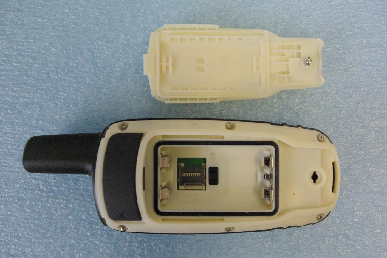
Click to zoom
Application Details
- Equipment Class
- DXX - Part 15 Low Power Communication Device Transmitter
- Date of Grant
- Jan 13, 2014
- Application Purpose
- Original Equipment
- Date of Application
- Jan 13, 2014
- Equipment Note
- Low Power Transmitter (2400-2483.5 MHz)
- Frequency Range
- 2402.00000000 - 2480.00000000
- Company
- Garmin International Inc
- Country
- United States
Documents & Files
Document Text
Text extracted from the exhibit documents filed with the FCC. Open a document above to read the original.
Users Manual
O4AHGD00 Quick Start Manual December 2013190-01702-01_0APrinted in Taiwan Introduction WARNING See the Important Safety and Product Information guide in the product box for product warnings and other important information. Getting Started When using your device the first time, you should complete these tasks to set up the device and get to know the basic features. 1 Install the batteries (page 3). 2 Turn on the device ( page 5). 3 Register the device (page 9). 4 Acquire satellites (page 5). 5 Select to view the status page (page 10). 6 Mark a waypoint ( page 6). Device Overview À Internal GPS/GLONASS antenna Á Keys  Power key à Mini-USB port (under weather cap) Ä MCX connector for GPS antenna (under weather cap) Å microSD™ card slot (under batteries) Æ Battery compartment Ç Mounting spine È Battery cover D-ring 2 Battery Information WARNING The temperature rating for the device may exceed the usable range of some batteries. Alkaline batteries can rupture at high temperatures. Do not use a sharp object to remove batteries. CAUTION Contact your local waste disposal department to properly recycle the batteries. NOTICE Alkaline batteries lose a significant amount of their capacity as the temperature decreases. Use lithium batteries when operating the device in below freezing conditions. Installing the NiMH Battery Pack The device operates using the optional NiMH battery pack or two AA batteries (page 4). 1 Turn the D-ring counter-clockwise, and pull up to remove the cover. 2 Locate the battery pack À that came in the product box. 3 Insert the battery pack, observing polarity. 4 Gently press the battery pack into place. 5 Replace the battery cover, and turn the D-ring clockwise. Charging the Battery Pack NOTICE To prevent corrosion, thoroughly dry the mini-USB port, the weather cap, and the surrounding area before charging or connecting to a computer. Do not attempt to use the device to charge a battery that was not provided by Garmin ® . Attempting to charge a battery that was not provided by Garmin can damage the device and void the warranty. 3 Before you can connect the straight connector of the USB cable to your device, you may have to remove optional mount accessories. NOTE: The battery will not charge when outside the temperature range of 32° to 122°F (0° to 50°C). You can charge the battery using a standard wall outlet or a USB port on your computer. 1 Pull up the weather cap À from the mini-USB port Á . 2 Plug the small end of the USB cable into the mini-USB port. 3 Plug the USB end of the cable into the AC adapter or a computer USB port. 4 Plug the AC adapter into a standard wall outlet. When you connect the device to a power source, the device turns on. 5 Charge the battery completely. Installing Batteries The handheld device operates using two AA batteries (not included). Use NiMH or lithium batteries for best results. 1 Turn the D-ring counter-clockwise, and pull up to remove the cover. 2 Insert two AA batteries, observing polarity. 3 Replace the battery cover, and turn the D-ring clockwise. 4 Hold . 5 Select Setup > System > AA Battery Type. 4 6 Select Alkaline, Lithium, Traditional NiMH, or Precharged NiMH. Turning On the Device Hold . Acquiring Satellite Signals It may take 30 to 60 seconds to acquire satellite signals. 1 Go outdoors to an open area. 2 If necessary, turn on the device. 3 Wait while the device searches for satellites. A question mark flashes while the device determines your location. 4 Select to open the status page. shows the GPS/GLONASS signal strength. When the bars are green, the device has acquired satellite signals. Keys FINDSelect to open the search menu. MARKSelect to save your current location as a waypoint. QUITSelect to cancel or return to the previous menu or page. ENTERSelect to select options and acknowledge messages. MENUSelect to open the options menu for the page that is currently open. Select twice to open the main menu (from any page). PAGESelect to scroll through the main pages. Select , , , or to select menu options and move the map cursor. 5 INSelect to zoom in on the map. OUTSelect to zoom out on the map. Waypoints Waypoints are locations you record and store in the device. Creating a Waypoint You can save your current location as a waypoint. 1 Select MARK. 2 If necessary, select a field to make changes to the waypoint. 3 Select Done. Navigating to a Waypoint 1 From the main menu, select FIND > Waypoints. 2 Select a waypoint. 3 Select Go. Editing a Waypoint Before you can edit a waypoint, you must create a waypoint. 1 Select Waypoint Manager. 2 Select a waypoint. 3 Select an item to edit, such as the name. 4 Enter the new information, and select Go. Deleting a Waypoint 1 Select Waypoint Manager. 2 Select a waypoint. 3 Select MENU > Delete. Routes A route is a sequence of waypoints or locations that leads you to your final destination. Creating a Route 1 Select Route Planner > Create Route > Select First Point. 2 Select a category. 3 Select the first point in the route. 4 Select Use. 5 Select Select Next Point to add additional points to the route. 6 Select QUIT to save the route. Navigating a Saved Route Before you can navigate using a saved route, you must create a route. 1 Select FIND > Routes. 2 Select a route. 6 3 Select Go. Tracks A track is a recording of your path. The track log contains information about points along the recorded path, including time, location, and elevation for each point. Viewing the Current Track 1 From the main menu, select Track Manager > Current Track. 2 Select an option: • To show the current track on the map, select View Map. • To show the elevation plot for the current track, select Elevation Plot. Navigating a Saved Track Before you can navigate a saved track, you must save a track. 1 Select FIND > Tracks. 2 Select a saved track. 3 Select Go. Map represents your location on the map. As you travel, moves and leaves a track log (trail). Waypoint names and symbols appear on the map. When you are navigating …
Text truncated - open the document above for the full version.
Users Manual
Important Safety and Product Information ������������������������������������������������������2 Informations importantes relatives au produit et à la sécurité ������������������������5 Informazioni importanti sulla sicurezza e sul prodotto ������������������������������������8 Wichtige Sicherheits- und Produktinformationen ������������������������������������������11 Información importante sobre el producto y tu seguridad ����������������������������14 Informações Importantes de Segurança e do Produto ���������������������������������16 Belangrijke veiligheids- en productinformatie �����������������������������������������������19 Vigtige produkt- og sikkerhedsinformationer ������������������������������������������������22 Tärkeitä turvallisuus- ja tuotetietoja ��������������������������������������������������������������24 Viktig sikkerhets- og produktinformasjon ������������������������������������������������������26 Viktig säkerhets- och produktinformation �����������������������������������������������������28 Ważne informacje dotyczące bezpieczeństwa i produktu ����������������������������31 Důležité bezpečnostní informace a informace o produktu ����������������������������34 Правила техники безопасности и сведения об изделии ��������������������������36 Pomembne informacije o varnosti in izdelku ������������������������������������������������40 Važne informacije o proizvodu i sigurnosti ���������������������������������������������������42 190-00720-24_0E.indd 19/24/2013 11:58:28 AM 2 Important Safety and Product Information WARNING Failure to avoid the following potentially hazardous situations could result in an accident or collision resulting in death or serious injury. Installation Warnings • When installing the device in a vehicle, place the device securely so it does not obstruct the driver’s view of the road ➊ or interfere with vehicle operating controls, such as the steering wheel, foot pedals, or transmission levers. Do not place unsecured on the vehicle dashboard ➋. Do not place the device in front of or above any airbag ➌. ➋ ➌ ➊ • The windshield mount may not stay attached to the windshield in all circumstances. Do not place the mount where it will become a distraction if it should become detached. Keep your windshield clean to help ensure that the mount stays on the windshield. Off-Road Navigation Warnings Some Garmin recreational products are able to suggest off-road routes for various outdoor activities, such as biking, hiking, and all-terrain vehicles. Follow these guidelines to ensure safe off-road navigation. • Always use your best judgment and exercise common sense when making off-road navigational decisions. The Garmin device is designed to provide route suggestions only. It is not a replacement for attentiveness and proper preparation for outdoor activities. Do not follow the route suggestions if they suggest an illegal course or would put you in an unsafe situation. • Always carefully compare information displayed on the device to all available navigation sources, including trail signs, trail conditions, weather conditions, and other factors that may affect safety while navigating. For safety, always resolve any discrepancies before continuing navigation, and defer to posted signs and conditions. • Always be mindful of the effects of the environment and the inherent risks of the activity before embarking on off-road activities, especially the impact that weather and weather-related trail conditions can have on the safety of your activity. Ensure that you have the proper gear and supplies for your activity before navigating along unfamiliar paths and trails. Street Navigation Warnings Some Garmin recreational products are able to accept street maps and suggest routes that follow roads. Follow these guidelines to ensure safe on-road navigation. • Always use your best judgment, and operate the vehicle in a safe manner. Do not become distracted by the device while driving, and always be fully aware of all driving conditions. Minimize the amount of time spent viewing the device screen while driving. • Do not input destinations, change settings, or access any functions requiring prolonged use of the device controls while driving. Pull over in a safe and legal manner before attempting such operations. • When navigating, carefully compare information displayed on the device to all available navigation sources, including road signs, road closures, road conditions, traffic congestion, weather conditions, and other factors that may affect safety while driving. For safety, always resolve any discrepancies before continuing navigation, and defer to posted signs and conditions. • The device is designed to provide route suggestions. It is not a replacement for driver attentiveness and good judgement. Do not follow route suggestions if they suggest an illegal maneuver or would place the vehicle in an unsafe situation. Battery Warnings Your GPS device uses user-replaceable batteries. If these guidelines are not followed, the batteries may experience a shortened life span or may present a risk of damage to the device, fire, chemical burn, electrolyte leak, and/or injury. • Do not leave the device exposed to a heat source or in a high-temperature location, such as in the sun in an unattended vehicle. To prevent damage, remove the device from the vehicle or store it out of direct sunlight, such as in the glove box. • Do not use a sharp object to remove the batteries. 190-00720-24_0E.indd 29/24/2013 11:58:28 AM 3 • Do not puncture or incinerate the device or battery. • Keep the batteries away from children. • Never put batteries in mouth. If swallowed, contact a physician or poison control center. • Do not disassemble, puncture, or damage the batteries. • Only replace the battery with the correct replacement battery. Using another battery presents a risk of fire or explosion. • Replaceable coin cell batteries may contain perchlorate material. Special handling may apply. See …
Text truncated - open the document above for the full version.
Cover Letter(s)
Page 1 of 2 December 20, 2013 Timco Engineering Inc. 849 NW State Road 45 Newberry, FL 32669 Applicant: Garmin International, Inc. 1200 East 151st Street Olathe, KS 66062 Re: Confidentiality for submittal information regarding FCC ID number IPH-02401 PRODUCT: Low power Transmitters operated under paragraph 15.249 Dear Sirs: Garmin International, Inc. requests that the material in the Schematics, Block Diagram, and Operational Description be withheld from public disclosure pursuant to Sections 0.457 and 0.459 of the Commission’s Rules following grant of the application. In support of this request, Garmin International, Inc. submits the following information. CONFIDENTIAL FILES Conf BlkDia O4AHGD00.pdf Conf OpDes O4AHGD00.pdf Conf Schem O4AHGD00.pdf 1. Identification of the specific information for which confidential treatment is sought: The materials set forth in the Operational Description, block diagram, parts list, and Schematics, which are segregated, from the non-confidential exhibits of the application, are those for which confidentiality is sought. 2. Identification of the Commission proceeding in which the information was submitted or a description of the circumstances giving rise to the submission: The proceeding is that involving the application for equipment authorization (certification) under FCC ID No: IPH-02401 3. Explanation of the degree to which the information is commercial or financial, or contains a trade secret or is privileged: This material includes a detailed theory of operation, circuit diagrams, and schematic. As such, this material is treated as highly confidential business information. ROGERS LABS, INC. 4405 West 259 th Terrace Louisburg, KS 66053 913 837-3214 Page 2 of 2 4. Explanation of the degree to which the information concerns a service that is subject to competition: The material for which confidentiality is sought is employed in the design and manufacture of this transmitting equipment that is offered on a highly competitive basis. Customers for this equipment have a variety of competing sources. 5. Explanation of how disclosure of the information could result in substantial competitive harm: Disclosure would, in effect, give away the fruits of the labors of Garmin International, Inc.’s engineering personnel, who have designed the equipment and the manufacturing process. Disclosure would also offer competitors additional unwarranted insight into the state of the product development, thereby allowing competitors an advantage, not available to Garmin International, Inc. 6. Identification of any measures taken by the submitting party to prevent unauthorized disclosure: The information for which confidential treatment is sought is kept confidential by Garmin International, Inc. and not made available to third parties except pursuant to non-disclosure agreements. 7. Identification of whether the information is available to the public and the extent of any previous disclosure of the information to third parties: To the knowledge of those preparing this application, the information has not been disclosed publicly heretofore. While the general theory of operation of this equipment has been the subject of numerous disclosures in industry and standards groups as well as in rule making proceedings of the FCC, the protection sought is narrowly drawn and pertains to certain specific implementations of this radio technology. 8. Justification of the period during which the submitting party asserts that the material should not be available for public disclosure: This material should not be disclosed for at least 25 years. While improvements in design are made relatively frequently, disclosure of the design information would lead to insights into both design and manufacturing techniques that could have an adverse competitive effect for many years to come. As such, it is important that the design not be made available to unauthorized persons who might attempt to use knowledge of the design to compromise the applications for which the equipment will be employed. Should you require any further information, please contact the undersigned. Thank you for your consideration in this matter. Sincerely, Scot Rogers
Cover Letter(s)
December 20, 2013 Timco Engineering Inc. 849 NW State Road 45 Newberry, FL 32669 Applicant: Garmin International, Inc. 1200 East 151st Street Olathe, KS 66062 Re: Short-term Confidentiality request for submittal information regarding FCC ID: IPH-02401 FCC Rules: Parts 2 and 15C Dear Sirs: Garmin International, Inc. requests that the following information be withheld from public disclosure pursuant to CFR47 paragraphs 0.457 and 0.459, and KDB 726920 until 180 days after the Grant of Equipment Authorization. Disclosure of information would offer competitors additional unwarranted insight into the state of the product development. Short-term confidential files Exhibit File External Photos Short Term Conf ExtPho O4AHGD00.pdf Internal Photos Short Term Conf IntPho O4AHGD00.pdf Test Setup Photos Short Term Conf TSup O4AHGD00.pdf User Manual Short Term Conf UserMan O4AHGD00.pdf User Manual Short Term Conf UserMan O4AHGD00 2.pdf Should you require any further information, please contact the undersigned. Thank you for your consideration in this matter. Sincerely, Scot Rogers ROGERS LABS, INC. 4405 West 259 th Terrace Louisburg, KS 66053 +1 913 837-3214
External Photos
Rogers Labs, Inc. Garmin International, Inc. SN: 3873075132B 4405 W. 259th Terrace Models: O4AHGD00 FCC ID#: IPH-02401 Louisburg, KS 66053 Test #: 131021 IC: 1792A-02401 Phone/Fax: (913) 837-3214 Test to: CFR47 (15.249), RSS-210 Date: December 20, 2013 Revision 1 File: Short Term Conf ExtPho O4AHGD00 Page 1 of 3 External photographs of equipment under test Rogers Labs, Inc. Garmin International, Inc. SN: 3873075132B 4405 W. 259th Terrace Models: O4AHGD00 FCC ID#: IPH-02401 Louisburg, KS 66053 Test #: 131021 IC: 1792A-02401 Phone/Fax: (913) 837-3214 Test to: CFR47 (15.249), RSS-210 Date: December 20, 2013 Revision 1 File: Short Term Conf ExtPho O4AHGD00 Page 2 of 3 Rogers Labs, Inc. Garmin International, Inc. SN: 3873075132B 4405 W. 259th Terrace Models: O4AHGD00 FCC ID#: IPH-02401 Louisburg, KS 66053 Test #: 131021 IC: 1792A-02401 Phone/Fax: (913) 837-3214 Test to: CFR47 (15.249), RSS-210 Date: December 20, 2013 Revision 1 File: Short Term Conf ExtPho O4AHGD00 Page 3 of 3
ID Label/Location Info
Label Drawing and Placement Note: All text is minimum 4 point font or larger Label is located on the device behind the back battery door cover Back of device Label Device
Internal Photos
Rogers Labs, Inc. Garmin International, Inc. SN: 3873075132B 4405 W. 259th Terrace Models: O4AHGD00 FCC ID#: IPH-02401 Louisburg, KS 66053 Test #: 131021 IC: 1792A-02401 Phone/Fax: (913) 837-3214 Test to: CFR47 (15.249), RSS-210 Date: December 20, 2013 Revision 1 File: Short Term Conf IntPho O4AHGD00 Page 1 of 1 Internal Photographs
Test Report
NVLAP Lab Code 200087-0 Rogers Labs, Inc. Garmin International, Inc. SN: 3873075132B 4405 W. 259th Terrace Models: O4AHGD00 FCC ID#: IPH-02401 Louisburg, KS 66053 Test #: 131021 IC: 1792A-02401 Phone/Fax: (913) 837-3214 Test to: CFR47 (15.249), RSS-210 Date: January 7, 2014 Revision 1 File: Garmin O4AHGD00 TstRpt 131021 Page 1 of 33 Application For Grant of Certification FOR FOR Model: O4AHGD00 2402-2480 MHz Low Power Transmitter FCC ID: IPH-02401 IC: 1792A-02401 FOR Garmin International, Inc. 1200 East 151st Street Olathe, KS 66062 Test Report Number: 131021 Authorized Signatory: Scot D. Rogers NVLAP Lab Code 200087-0 Rogers Labs, Inc. Garmin International, Inc. SN: 3873075132B 4405 W. 259th Terrace Models: O4AHGD00 FCC ID#: IPH-02401 Louisburg, KS 66053 Test #: 131021 IC: 1792A-02401 Phone/Fax: (913) 837-3214 Test to: CFR47 (15.249), RSS-210 Date: January 7, 2014 Revision 1 File: Garmin O4AHGD00 TstRpt 131021 Page 2 of 33 Engineering Test Report For Grant of Certification Application FOR CFR 47, PART 15C - Intentional Radiators CFR 47 Paragraph 15.249 and Industry Canada RSS-210 License Exempt Intentional Radiator For Garmin International, Inc. 1200 East 151st Street Olathe, KS 66062 Model: O4AHGD00 Low Power Transmitter Frequency Range 2402-2480 MHz FCC ID#: IPH-02401 IC: 1792A-02401 Test Date: October 21, 2013 Certifying Engineer: Scot D. Rogers Rogers Labs, Inc. 4405 West 259 th Terrace Louisburg, KS 66053 Telephone/Facsimile: (913) 837-3214 This report shall not be reproduced except in full, without the written approval of the laboratory. This report must not be used by the client to claim product certification, approval, or endorsement by NVLAP, NIST, or any agency of the Federal Government. ROGERS LABS, INC. 4405 West 259 th Terrace Louisburg, KS 66053 Phone / Fax (913) 837-3214 NVLAP Lab Code 200087-0 Rogers Labs, Inc. Garmin International, Inc. SN: 3873075132B 4405 W. 259th Terrace Models: O4AHGD00 FCC ID#: IPH-02401 Louisburg, KS 66053 Test #: 131021 IC: 1792A-02401 Phone/Fax: (913) 837-3214 Test to: CFR47 (15.249), RSS-210 Date: January 7, 2014 Revision 1 File: Garmin O4AHGD00 TstRpt 131021 Page 3 of 33 Table Of Contents TABLE OF CONTENTS .................................................................................................. 3 REVISIONS ..................................................................................................................... 4 FORWARD ..................................................................................................................... 5 OPINION / INTERPRETATION OF RESULTS ............................................................... 5 EQUIPMENT TESTED .................................................................................................... 5 EQUIPMENT FUNCTION AND CONFIGURATION........................................................ 6 Equipment Configuration.................................................................................................................................... 7 APPLICATION FOR CERTIFICATION ........................................................................... 8 APPLICABLE STANDARDS & TEST PROCEDURES .................................................. 9 EQUIPMENT TESTING PROCEDURES ........................................................................ 9 AC Line Conducted Emission Test Procedure .................................................................................................. 9 Diagram 1 Test arrangement for Conducted emissions ..................................................................................... 10 Radiated Emission Test Procedure ................................................................................................................... 11 Diagram 2 Test arrangement for radiated emissions of tabletop equipment ...................................................... 11 Diagram 3 Test arrangement for radiated emissions tested on Open Area Test Site (OATS) ........................... 12 TEST SITE LOCATIONS .............................................................................................. 13 UNITS OF MEASUREMENTS ...................................................................................... 13 ENVIRONMENTAL CONDITIONS................................................................................ 13 LIST OF TEST EQUIPMENT ........................................................................................ 14 INTENTIONAL RADIATORS ........................................................................................ 15 Antenna Requirements ...................................................................................................................................... 15 Restricted Bands of Operation .......................................................................................................................... 15 Table 1 Harmonic Radiated Emissions in Restricted Bands Data ..................................................................... 16 Summary of Results for Radiated Emissions in Restricted Bands ................................................................ 16 NVLAP Lab Code 200087-0 Rogers Labs, Inc. Garmin International, Inc. SN: 3873075132B 4405 W. 259th Terrace Models: O4AHGD00 FCC ID#: IPH-02401 Louisburg, KS 66053 Test #: 131021 IC: 1792A-02401 Phone/Fax: (913) 837-3214 Test to: CFR47 (15.249), RSS-210 Date: January 7, 2014 Revision 1 File: Garmin O4AHGD00 TstRpt 131021 Page 4 of 33 AC Line Conducted EMI Procedure ................................................................................................................ 17 Figure 1 AC Line Conducted emissions of EUT line 1 (EUT AC Adapter) ..................................................... 18 Figure 2 AC Line Conducted emissions of EUT line 2 (EUT AC Adapter) ..................................................... 18 Figure 3 AC Line Conducted emissions of EUT line 1 (EUT-USB-CPU) ..............................................…
Text truncated - open the document above for the full version.
Test Setup Photos
Rogers Labs, Inc. Garmin International, Inc. SN: 3873075132B 4405 W. 259th Terrace Models: O4AHGD00 FCC ID#: IPH-02401 Louisburg, KS 66053 Test #: 131021 IC: 1792A-02401 Phone/Fax: (913) 837-3214 Test to: CFR47 (15.249), RSS-210 Date: December 20, 2013 Revision 1 File: Short Term Conf TSup O4AHGD00 Page 1 of 1 Test setup photographs
Contact Information
Applicant
Ben Karsak(Manager, Compliance Engineering)
Test Firm
Rogers Labs, a division of The Compatibility CntrPatrick Powell
Technical Specifications
| # | Rule Parts | Frequency Range | Power Output |
|---|---|---|---|
| 1 | 15C | 2.40 GHz - 2.48 GHz | - |
Other Applications from Garmin International Inc
IPH-05170
Aug 05, 2026Transceiver
Equipment Class
DTS - Digital Transmission SystemIPH-A5192
Jul 21, 2026Fitness product
Equipment Class
DXX - Part 15 Low Power Communication Device TransmitterIPH-0P3039
Jul 07, 2026Outdoor Product
Equipment Class
DTS - Digital Transmission SystemIPH-04286
Jul 06, 2026Digital Transmission System Transceiver
Equipment Class
DTS - Digital Transmission SystemIPH-04292
Jul 06, 2026Digital Transmission System Transceiver
Equipment Class
TNB - Licensed Non-Broadcast Station Transmitter