SY4-A02028Unmanned Surface Vessel
Shanghai Huace Navigation Technology Ltd.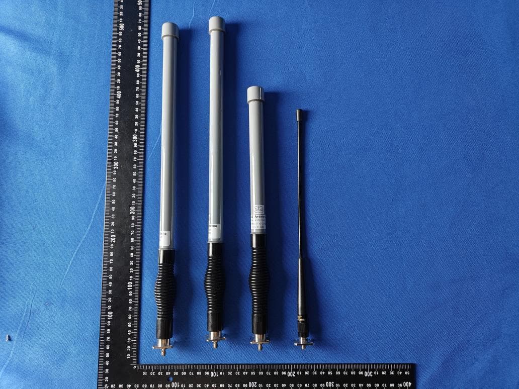
Click to zoom
Application Details
- Equipment Class
- PCB - PCS Licensed Transmitter
- Date of Grant
- Jul 01, 2024
- Application Purpose
- Original Equipment
- Date of Application
- Jun 24, 2024
- Equipment Note
- Unmanned Surface Vessel
- Frequency Range
- 2506.00000000 - 2680.00000000
- Country
- China
Documents & Files
Document Text
Text extracted from the exhibit documents filed with the FCC. Open a document above to read the original.
Users Manual
User Manual for CHCNAV APACHE USV @2024 Shanghai Huace Navigation Technology Co., Ltd. Copyright CONTENTS 1. Product Overview .................................................................. 9 1.1 Introduction ............................................................................................................... 9 1.2 Product Features ........................................................................................................ 9 1.3 Usv Assembly Equipment List .................................................................................. 9 1.4 Acessories Of Boat Introduction ............................................................................. 10 1.5 Introduction To Remote Control Components ........................................................ 12 2. APACHE Series USVs ........................................................ 13 2.1 GD100 (Main Control System) ............................................................................... 14 2.2 Indicators On USV .................................................................................................. 15 2.3 Motor ....................................................................................................................... 16 2.4 Replacing The Motor Or Propeller .......................................................................... 16 2.5 Camera .................................................................................................................... 17 2.6 Millimeter Wave Obstacle Avoidance Module ........................................................ 17 2.7 The Case For Batteries ............................................................................................ 17 2.7.1 Battery ............................................................................................................. 17 2.7.2 Battery Usage Guide ....................................................................................... 18 2.7.3 Battery Storage ................................................................................................ 18 2.7.4 Battery Charger Usage .................................................................................... 18 2.7.5 Charger Specification ...................................................................................... 20 2.7.5.1 Input Characteristics:....................................................................................... 20 2.7.5.2 Output Characteristics: .................................................................................... 20 2.7.5.3 Environmental Characteristics: ....................................................................... 21 3. Remote control..................................................................... 22 3.1 HC10 Remote Control ............................................................................................. 23 3.2 Remote Control Charging ....................................................................................... 24 3.3 Operating Environment Conditions......................................................................... 24 3.4 Remote Control Maintenance And Repair .............................................................. 25 3.5 Remote Transportation And Storage ....................................................................... 25 4. EasySail App ........................................................................ 26 4.1 easysail Overview ................................................................................................... 27 4.2 Easysail Software Operating Environment ............................................................. 27 4.3 Easysail Installation/Uninstallation/Data Cleanup .................................................. 28 4.3.1 Download and Installation .............................................................................. 28 4.3.2 Software Permissions ...................................................................................... 28 User Manual for CHCNAV APACHE USV @2024 Shanghai Huace Navigation Technology Co., Ltd. Copyright 4.4 Software Description ............................................................................................... 29 4.5 Login Account ......................................................................................................... 30 4.6 Quick Start Guide .................................................................................................... 31 4.6.1 Connect to boat ............................................................................................... 31 4.6.2 Plan the route ................................................................................................... 32 4.6.3 Device connection ........................................................................................... 32 4.7 Project Management ................................................................................................ 34 4.8 New Project/Coordinate System ............................................................................. 35 4.9 Check Itself ............................................................................................................. 39 4.10 Mission Plan ............................................................................................................ 40 4.10.1 Han d-drawn ..................................................................................................... 40 4.10.2 Route planning ................................................................................................ 40 4.10.3 Generate Polygon from Trajectory .................................................................. 41 4.10.4 Import file........................................................................................................ 43 4.11 Settings .................................................................................................................... 45 4.11.1 Record Control ...................…
Text truncated - open the document above for the full version.
Users Manual
User Manual for CHCNAV APACHE USV @2024 Shanghai Huace Navigation Technology Co., Ltd. Copyright If you are using a bridge connection, you need to change your computer's IP address to the 53 subnet. However, you cannot use the following IP addresses: 192.168.53.254, 192.168.53.64, 192.168.53.20, 192.168.53.19 as they are already being used. After the connection is established, you can find the current basic information in the bottom right corner of the homepage. It includes the longitude, latitude, altitude, GPS status, number of satellites, speed, status of battery 1, and status of battery 2. The current signal status is displayed in the top left corner. User Manual for CHCNAV APACHE USV @2024 Shanghai Huace Navigation Technology Co., Ltd. Copyright 5.1.2 Login Camera Under 4G connection status (external network): Click on the Expand/Hide Attitude Display and Video in the upper left corner of the page, click on Intranet Network, enter the Username is admin, password is Admin1234, port is 8000, and the IP is 192.168.0.254 and then click on Start - Play to open the camera. Under TCP connection status (internal network): Username is admin, password is Admin1234, port is 8000, and the IP is 192.168.53.64. 5.1.3 Parameters Display User Manual for CHCNAV APACHE USV @2024 Shanghai Huace Navigation Technology Co., Ltd. Copyright [Expand/Collapse Attitude Display and Video] Displays the vessel's attitude, expand to show the camera; [Expand/Collapse Remote Control] Check button control, control the unmanned vessel using WASD, control the camera using up, down, left, and right; [Open/Close Auto Button] After setting the route and sending it to GD100, open the automatic mode, and the unmanned vessel will start operating on the preset route. [Expand/Collapse Settings] [Set Waypoint] Sets the initial waypoint of the unmanned vessel, which is the first point when the unmanned vessel is in automatic mode; [Next Waypoint] The next waypoint of the unmanned vessel in automatic mode; [Clear Track] Clears the current planned route on the base map; [Auto/Manual/Standby/Return/Guide] Switches the current working mode of the unmanned vessel; [One-Click Hover] Select the corresponding waypoint to switch between manual mode, automatic return, and hover; Parameter information column, the display area for regular parameters, double-click to switch to the corresponding real-time display parameters; [Switch Map] Switches to different maps, such as Amap, Google Maps, Bing Maps, etc. Different image maps may have deviations in accuracy, choose the most suitable image map based on the field conditions. If the network is poor in the field measurement area, you can preload the satellite image indoors; [Auto Pan] When selected, the vessel remains centered; [Battery and Signal Strength Display] Displays the current battery level and network signal strength; [Hide] Shows or hides the current status information of the unmanned vessel; [Status Information Column] Displays the current status information of the unmanned vessel; [Zoom] Zooms the map display, scroll up to zoom in and scroll down to zoom out using the mouse wheel. User Manual for CHCNAV APACHE USV @2024 Shanghai Huace Navigation Technology Co., Ltd. Copyright 5.1.4 Navigation Plan 5.1.4.1 Page Status Display ① [GEO, UTM, MGRS] are different coordinate systems, which are respectively the geodetic coordinate system, the unified transverse Mercator projection system, and the UTM -based military grid reference system (MGRS) latitude and longitude system. Generally, the default is latitude and longitude coordinates. ② Check [Grid] to display grid lines. ③ [Switch Map] to switch to different maps, such as Amap, Google Maps, Bing Maps, etc. Different imagery maps may have deviations in accuracy. Choose the most suitable imagery map based on the field conditions. If the field survey area has poor network connectivity, pre-load satellite imagery indoors. ④ [Load Task Point File] to load previously saved task point files. [Save Task Point File] to save the currently planned flight route. [Read Task Point] to read the current task waypoints from the controller. [Write Task Point] to transfer the planned waypoint data to the controller. △ !Note: The file import does not support a large number of waypoints, with a maximum limit of 300. User Manual for CHCNAV APACHE USV @2024 Shanghai Huace Navigation Technology Co., Ltd. Copyright ⑤ [Starting Position Coordinates] Displays the coordinate information of the initial position; ⑥ [Operating Mode] Includes four modes: surveying, hydrological, fully automatic, and semi-automatic. (Only unmanned boats equipped with millimeter wave obstacle avoidance radar can use the fully automatic and semi-automatic functions, and the obstacle recognition angle needs to be >45°) ⑦ [Pre -set Route] The top left corner displays the route mileage, bearing information from the previous point, and distance from home; ⑧ [Waypoint List] Allows modification of point coordinates, deletion, and sorting; ⑨ [Mark Waypoint at Boat's Location] Adds a waypoint at the boat's current location; [Clear Mission] Clears all waypoints added on the current interface; [Auto Pan] When selected, the boat remains centered; [Polygon Expansion/Contraction] Expands or contracts the polygon, clicking once expands internally or contracts externally by 0.5m; ⑩ [Waypoint] Left-click on the map to add waypoints, right-click on a selected waypoint to delete; User Manual for CHCNAV APACHE USV @2024 Shanghai Huace Navigation Technology Co., Ltd. Copyright 5.1.4.2 Right-Click Menu Bar Function Insert/Delete Waypoints: Select the desired location to add a waypoint, and click the left mouse button to add the waypoint. To delete a selected waypoint, right-click on it. Hover: Control the unmanned vessel to hover at a specific location. Jump: After the unmanned vessel completes the preset route operation, it will continue to operate based on the preset jump points and repetition count. For e…
Text truncated - open the document above for the full version.
Users Manual
User Manual for CHCNAV APACHE USV @2024 Shanghai Huace Navigation Technology Co., Ltd. Copyright Click on "Data Processing - Data Export", or click on the "Export" button in the shortcut bar )open the saved HTT file, Check "File Merge" to merge and export multiple HTT data into one file; Check "Export Header" to export the result file of the data, supporting header export; You can choose the file type to export, including dat, txt, CSV, and dxf types; Format selection: Select a format from the drop-down list, and select the custom option to create a new format yourself; Click "Export" to export the selected format data; Click "Delete" to delete the selected format (only supports custom added data formats); User Manual for CHCNAV APACHE USV @2024 Shanghai Huace Navigation Technology Co., Ltd. Copyright 7.11.1 UAV cross-section export Click "Data Processing - Drone Section Export", open the HTT file, fill in the relevant parameter information, and click "Table Export" to generate an xls file; Click "one click upload" to automatically upload to the drone flow measurement platform server, and generate flow measurement routes at the same time. 7.12 Support 7.12.1 Software registration The CHCNAV series USV do not require registration. If using depth sounders and other positioning and navigation equipment, a software dog or machine code registration activation is required. 7.12.2 Online upgrade Click on online upgrade to automatically detect the latest version of the software. Release note User Manual for CHCNAV APACHE USV @2024 Shanghai Huace Navigation Technology Co., Ltd. Copyright 7.12.3 User's manual 7.12.4 Understanding Huawei Click to learn about CHCNAV APCHE series USV, follow the [Huawei Tour World] official account by scanning the WeChat code, and check the operation manual/video/FAQ/technical bulletin online. User Manual for CHCNAV APACHE USV @2024 Shanghai Huace Navigation Technology Co., Ltd. Copyright 7.12.5 Language selection Supports switching between Chinese, English, and Russian languages, effective after restarting the software. Unit selection Supports switching between distance and temperature unit displays, Distance: meters/US feet/International feet. Temperature: Celsius/Fahrenheit. User Manual for CHCNAV APACHE USV @2024 Shanghai Huace Navigation Technology Co., Ltd. Copyright 7.12.6 About Software View the current version of HydroSurvey software. When the depth sounder is turned on, the corresponding firmware version of the depth sounder can be displayed. 7.13 Other functions 7.13.1 Waveform printing This function requires connecting the printer (real-time printing and playback printing), installing the driver, and setting printer configuration parameters in order to print normally. When setting up PDF saving, it can be directly saved to a PDF file without the need for a connection. Printer model: Brother PJ-763MFi Printer driver: can be obtained by contacting technical personnel; "Waveform Printing": Click on the "Waveform Printing" button in the shortcut bar 。 Printing methods: real-time printing, playback printing, PDF saving; Engineering information: print head information; Horizontal width: printing horizontal time intervals; 7.13.1.1 Real Time Printing User Manual for CHCNAV APACHE USV @2024 Shanghai Huace Navigation Technology Co., Ltd. Copyright After setting the parameters, click the "Start Printing" button and "Start" recording to achieve real-time waveform printing while measuring and recording data; Real time printing, waveform renderings cannot be previewed; 7.13.1.2 Playback Printing In the waveform file list, select the corresponding file and click the "Start Printing" button. Double click on the file to preview the waveform effect in the left view; Attention: When the file is large, wait for a moment as uploading the data to the printer takes time; User Manual for CHCNAV APACHE USV @2024 Shanghai Huace Navigation Technology Co., Ltd. Copyright 7.13.1.3 PDF Save In the waveform file list, select the corresponding file and click "Start Printing". Below the file list, you can view the current progress of file processing. The file is automatically stored in the Result directory under the current project, and the PDF file content is displayed: 7.13.1.4 End Printing Click on the shortcut bar and click on the "End Printing" button , end current real-time printing, invalid for playback printing function. User Manual for CHCNAV APACHE USV @2024 Shanghai Huace Navigation Technology Co., Ltd. Copyright 8. Navigation operations Please install and operate the equipment under the guidance of APACHE series USV professional technicians after completing the training and teaching of Huace USVs. When operating USVs, please plan the path reasonably based on the on-site working environment and adopt appropriate methods for accurate and efficient measurement. 9. Navigation environment requirements In extremely bad weather, to ensure the safety of work equipment and personnel, please do not conduct measurements. Please avoid operating near high-voltage power lines, communication base stations, and signal towers, as the remote control may be affected by interference in this environment. Please use with caution in complex aquatic environments such as turbulent water flow and navigation channels. 10. Pre homework check USVs and remote control batteries are fully charged. The USV antenna, hatch cover, etc. are all tightened in place The motor rotates normally without any abnormal noise and the wind direction is correct. The USV (4G/data transmission) has stable communication, and the depth sounder and positioning equipment are working properly. If automatic navigation is required, check if the route is within the water area and if the Home point is reasonable. User Manual for CHCNAV APACHE USV @2024 Shanghai Huace Navigation Technology Co., Ltd. Copyright 11. APPENDIX User Manual for CHCNAV APACHE USV @2024 Shanghai Huace Navigation Technology Co., Ltd. Copyright 11.1 Product Para…
Text truncated - open the document above for the full version.
Attestation Statements
Shanghai Huace Navigation Technology Ltd. Covered Equipment Certification Attestation Letter 1/24/2024 Nemko North America, Inc. 303 River Road Ottawa K1V 1H2 Canada ATTN.: Reviewing Engineer FCC ID: SY4-A02028 Shanghai Huace Navigation Technology Ltd. (“the applicant”) certifies that the equipment for which authorization is sought is not “covered” equipment prohibited from receiving an equipment authorization pursuant to section 2.903 of the FCC rules. Note: If the equipment for which the applicant seeks authorization is produced by any of the entities identified on the current Covered List, the applicant should include an explanation on why the equipment is not “covered” equipment. Shanghai Huace Navigation Technology Ltd. (“the applicant”) certifies that, as of the date of the filing of the application, the applicant is not identified on the Covered List as an entity producing “covered” equipment. Signed: Printed name: Glenn Chu Title: Certification Manager Company Name: Shanghai Huace Navigation Technology Ltd. Date: 1/24/2024
Attestation Statements
Shanghai Huace Navigation Technology Ltd. * the applicant must designate a contact located in the United States for purposes of acting as the applicant’s agent for service of process, regardless of whether the applicant is a domestic or foreign entity. An applicant located in the United States may designate itself as the agent for service of process. U.S. Agent Designation for Service of Process - Certification Attestation Letter 1/25/2024 Nemko North America, Inc. 303 River Road Ottawa K1V 1H2 Canada ATTN.: Reviewing Engineer FCC ID: SY4-A02028 FRN: 0022641393 Per section 2.911(d)(7) of the FCC rules, Shanghai Huace Navigation Technology Ltd. (“the applicant”) certifies that the equipment for which authorization is sought is designated to the following U.S. agent* for service of process: Company Name: iGage Mapping Corporation FRN: 0013933296 Physical U.S. Company Address: 1545 South 1100 East #1, Salt Lake City, UT 84105, United States Agent name: Mark E Silver Agent Email Address: [email protected] The above contact person accepts the obligation for service of process. The applicant accepts to maintain an agent for no less than one year after the grantee has terminated all marketing and importation or the conclusion of any Commission-related proceeding involving the equipment. Applicant Signed: Agent Signed (if different to Applicant): Signed: Printed name: Glenn Chu Title: Certification Manager Company Name: Shanghai Huace Navigation Technology Ltd. Date: 1/24/2024 Signed: Printed name: Mark E Silver Title: President Company Name: iGage Mapping Corporation Date: 1/24/2024
Cover Letter(s)
June 11, 2024 Nemko Canada Inc 303 River Road Ottawa, Ontario, Canada K1V 1H2 Attn: Director of Certification Authority to Act as Agent On our behalf, I appoint Shenzhen Alpha Product Testing Co., Ltd. Address: Building i, No.2, Lixin Road, Fuyong Street, Bao’an District, 518103, Shenzhen, Guangdong, China Person: Mark Zhu (Name and address,person). to act as our agent in the preparation of this application for equipment certification. I certify that submitted documents properly describe the device or system for which equipment certification is sought. I also certify that each unit manufactured, imported or marketed, as defined in the Federal Communications Commission’s regulations will have affixed to it a label identical to that submitted for approval with this application. For instances where our authorized agent signs the application for certification on our behalf, I acknowledge that all responsibility for complying with the terms and conditions for certification, as specified by Nemko Canada Inc, still resides with Shanghai Huace Navigation Technology Ltd. Address: 577 Songying Road, Qingpu District, 201706 Shanghai, China ( applicant name and address). Signature: Name Glenn Chu Position Certificate manager Company Name Shanghai Huace Navigation Technology Ltd. Address 577 Songying Road, Qingpu District, 201706 Shanghai, China Tel +86 755 29766001 Fax / Email [email protected]
Cover Letter(s)
June 11, 2024 Equipment Autorisation Division Federal Communications Commission 7435 Oakland Mills Road Columbia, MD 21046 FCC ID: SY4-A02028 Product Name: Unmanned Surface Vessel Request for Confidentiality Pursuant to Sections 0.457 and 0.459 of the commissions rules, we hereby request that the following documents be held confidential: Schematics Long-term confidential Block diagram Long-term confidential Operation description Long-term confidential These materials contain trade secrets and proprietary information and are not customarily released to the public. The public disclosure of this information might be harmful to the company and provide unjustified benefits to our competitors. Signature: Name Glenn Chu Position Certificate manager Company Name Shanghai Huace Navigation Technology Ltd. Address 577 Songying Road, Qingpu District, 201706 Shanghai, China Tel +86 755 29766001 Fax / Email [email protected]
Cover Letter(s)
Differences Description We Shanghai Huace Navigation Technology Ltd. state: Product name: Unmanned Surface Vessel Model: Apache 3, Apache 3 Pro, Apache 4 All models of all models of PCB design, software, electric circuit, radio frequency characteristics, appearance are consistent 2024-6-11 Name Glenn Chu Position Certificate manager Company Name Shanghai Huace Navigation Technology Ltd. Address 577 Songying Road, Qingpu District, 201706 Shanghai, China Tel +86 755 29766001 Fax / Email [email protected] (Signature)
External Photos
FCC ID: SY4-A02028 Model: Apache 3 2/3/4G ANT FCC ID: SY4-A02028 FCC ID: SY4-A02028 FCC ID: SY4-A02028 FCC ID: SY4-A02028 Model: Apache 3 Pro FCC ID: SY4-A02028 FCC ID: SY4-A02028 FCC ID: SY4-A02028 Model: Apache 4 FCC ID: SY4-A02028 FCC ID: SY4-A02028 FCC ID: SY4-A02028 FCC ID: SY4-A02028 FCC ID: SY4-A02028 2.4G ANT 2/3/4G ANT UHF ANT FCC ID: SY4-A02028 Internal photos: FCC ID: SY4-A02028 FCC ID: SY4-A02028 FCC ID: SY4-A02028 FCC ID: SY4-A02028 FCC ID: SY4-A02028 FCC ID: SY4-A02028 FCC ID: SY4-A02028 FCC ID: SY4-A02028 FCC ID: SY4-A02028
ID Label/Location Info
4.5cm 2.5cm Label Location FCC ID: SY4-A02028 Shanghai Huace Navigation Technology Ltd. Product name: Unmanned Surface Vessel Model No.: Apache 3 This device complies with Part 15 of the FCC Rules. Operation is subject to the following two conditions: (1) this device may not cause harmful interference, and (2) this device must accept any interference received, including interference that may cause undesired operation.
Internal Photos
FCC ID: SY4-A02028 FCC ID: SY4-A02028 FCC ID: SY4-A02028 FCC ID: SY4-A02028 FCC ID: SY4-A02028 FCC ID: SY4-A02028 FCC ID: SY4-A02028 FCC ID: SY4-A02028 FCC ID: SY4-A02028 FCC ID: SY4-A02028 FCC ID: SY4-A02028 FCC ID: SY4-A02028 FCC ID: SY4-A02028 FCC ID: SY4-A02028 FCC ID: SY4-A02028 FCC ID: SY4-A02028 FCC ID: SY4-A02028 FCC ID: SY4-A02028 FCC ID: SY4-A02028 FCC ID: SY4-A02028
RF Exposure Info
FCC ID: SY4-A02028 Prediction of MPE at a given distance 1. Limits The criteria listed in the following table shall be used to evaluate the environment impact of human exposure to radio frequency (RF) radiation as specified in 1.1307(b) 2. Test Procedure Equation from page 18 of OET Bulletin 65, Edition 97-01 Where: S = power density P = power input to the antenna G = numeric gain of the antenna in the direction of interest relative to an isotropic radiator R = distance to the centre of radiation of the antenna FCC ID: SY4-A02028 3. Result Worse case is as below: Mode Frequency (MHz) Prediction distance (cm) RF output power MPE (mW/cm 2 ) Limit (mW/cm 2 ) SAR Test Exclusion dBm mW 2.4G 2462 20 18.388 68.9922 0.0577 1 Yes GSM 848.80 20 30.96 1247.3835 0.5581 0.56586 Yes WCDMA 826.40 20 24.02 252.3481 0.1129 0.57493 Yes LTE 1880 20 23.74 236.5920 0.1284 1 Yes Maximum Simultaneous transmission MPE Ratios for 2.4G+GSM: Max MPE ratio 2.4G /Limit Max MPE ratio GSM /Limit ∑MPE ratios Limit Result 0.0577 0.5581 0.6158 1 PASS 2.4G Antenna Gain: 6.24dBi, 4.21(numeric) GSM&WCDMA Antenna Gain: 3.52dBi, 2.25(numeric) LTE Antenna Gain: 4.36dBi, 2.73(numeric) Meets MPE requirements, then SAR evaluation is not required.
Test Report
Add:No.30 Dongyang 3rd Road, Danzao Town, Nanhai District, Foshan City, Guangdong, China 528216 Tel: +86-757-88022860 Email: [email protected] Web: http://www.kenbotong.com 2400-250MHz Fiberglass Omni Antenna Electrical Specifications Frequency Range (MHz) 2400~2500 Bandwidth(MHz) 100 Polarization Vertical Gain (dBi) 6.24 Horizontal Beam Width(°) 360 Vertical Beam Width(°) 25 Horizontal unroundness(dB) ±1.5 Impedance (Ω) 50 VSWR ≤1.8 Maximum Input Power (W) 50 TQJ-2400TG6 Applications 2400-2500MHz Band Communications/ Wireless Data transmission System/ Wireless Paging System. Mechanical Specifications Connector Type N Male Connector Position Bottom Antenna Size (mm) φ29*(420±5) Antenna Weight (Kg) 0.3±0.05 Radome material Fiberglass Radome color Gray@Fiberglass Operating Temperature (°C) -40~+70 Relative Humidity(%) 5~95 Rated Wind Velocity (m/s) 55 Salt Spray Resistance 96Hour Neutral(GB/T 2423.17-2008) waterproofing grade IP65 Applications Outdoor Mounting M110N Magnetic or mounting with piggyback device Installation Sketch 3 Test results Test items technical requirement Unit Test results Det frequency range 2400-2500 MHz 2400-2500 PASS Gain 6±1 dBi 2400 MHz 6.23 PASS 2450 MHz 6.24 2500 MHz 6.14 Horizontal beamwidth 360 ° 2400 MHz 360 PASS 2450 MHz 360 2500 MHz 360 Vertical Beamwidth 25 ° 2400 MHz 23.04 PASS 2450 MHz 24.16 2500 MHz 23.15 Horizontal out of roundness ±1.5 dB 2400 MHz 0.36 PASS 2450 MHz 0.42 2500 MHz 0.38 Voltage standing wave ratio ≤1.8 / 1.26 1.33 1.31 PASS 4 Radiation pattern / / See attached image PASS Polarization mode Vertical / Vertical PASS PASS Voltage standing wave ratio 5 2D 频率 E面 H面 2400MHz 2450MHz 2500MHz
Test Report
Add:No.30 Dongyang 3rd Road, Danzao Town, Nanhai District, Foshan City, Guangdong, China 528216 Tel: +86-757-88022860 Email: [email protected] Web: http://www.kenbotong.com 806-960/1810-2700MHz Fiberglass Omni Antenna Electrical Specifications Frequency Range (MHz) 806~960/1710~2700 Band Width (MHz) 154/990 Polarization Vertical Gain (dBi) 4.76 Horizontal Beam Width(°) 360 Vertical Beam Width(°) 806~960@75±15 / 1710~2700@58±20 Omni Ripple(dB) ±1.5 Impedance (Ω) 50 VSWR ≤2.5 Maximum Input Power (W)@50°C 50 TQJ-0827TG3F19 Applications 4G Band Communications/ Wireless Data transmission System. Mechanical Specifications Connector Type N Male Connector Position Bottom-end of the Antenna Antenna Size (mm) Φ29(MAX)*(325±5) Antenna Weight (kg) 0.3±0.1 Radome Material Fiberglass Antenna Colour Black & Grey Operating Temperature (°C) -40~+70 Relative Humidity(%) 5~95 Rated Wind Velocity (m/s) 60 Salt Spray Resistance 96Hour Neutral(GB/T 2423.17-2008) Ingress Protection IP65 Applications Outdoor Mounting Installation with equipment Installation Sketch Product Pictures 3 Test results Test items Indicator requirements Testing frequency Port number Determine 806-960/1710-2690 Gain 3.5±1/4.5±1 806 3.11 PASS 880 3.24 960 3.52 1710 4.22 1880 4.21 1990 4.36 2170 4.45 2300 4.62 2500 4.59 2600 4.76 2690 4.63 E 面不圆度 360 806 360 PASS 880 360 960 360 1710 360 1880 360 1990 360 2170 360 2300 360 2500 360 2600 360 2690 360 E 面3dB宽度 75±15/58±20 806 77.6 PASS 880 76.35 960 64.2 1710 65.17 1880 67.61 1990 64.24 2170 60.35 2300 60.9 2500 62.99 2600 60.91 2690 59.29 Standing wave ratio <1.5 1.42 1.47 PASS Radiation pattern See attached image PASS Polarization mode Vertical / Vertical PASS PASS 4 Voltage standing wave ratio 5 2D 频率 E面 H面 806MHz 880MHz 960MHz 6 1710MHz 1880MHz 1990MHz 7 2170MHz 2300MHz 2500MHz 8 2600MHz 2690MHz
Test Report
ALPHA's reports is using a digital certificate that is trusted on Adobe's official server. If there is no digital certificate or the digital certificate shows damaged in your report. Please do not accept the report. E-mail: [email protected] Tel: 4008300895 Website: http://www.a-lab.cn/certificate FCC TEST REPORT FCC ID: SY4-A02028 On Behalf of Shanghai Huace Navigation Technology Ltd. Unmanned Surface Vessel Model No.: Apache 3, Apache 3 Pro, Apac…
Text truncated - open the document above for the full version.
Contact Information
Applicant
Glenn Chu
Test Firm
Shenzhen Alpha Product Testing Co., LTD.Real Yak
[email protected]+86 755 29766001
Technical Specifications
| # | Rule Parts | Frequency Range | Power Output | Emission | Tolerance |
|---|---|---|---|---|---|
| 29 | 27 | 2.51 GHz - 2.68 GHz | 233.88 mW | 17M8W7D | 2.5 ppm |
Other Applications from Shanghai Huace Navigation Technology Ltd.

SY4-A02076
Jul 16, 2026GNSS Receiver
Equipment Class
DTS - Digital Transmission SystemSY4-B01023
Jun 25, 2026Handheld GNSS Data Collector
Equipment Class
PCB - PCS Licensed Transmitter
SY4-A02075
Mar 30, 2026Surveying System
Equipment Class
NII - Unlicensed National Information Infrastructure TX
SY4-A02074
Mar 30, 2026Surveying System
Equipment Class
NII - Unlicensed National Information Infrastructure TX
SY4-B01022
Jan 23, 2026GNSS Data Collector
Equipment Class
NII - Unlicensed National Information Infrastructure TX